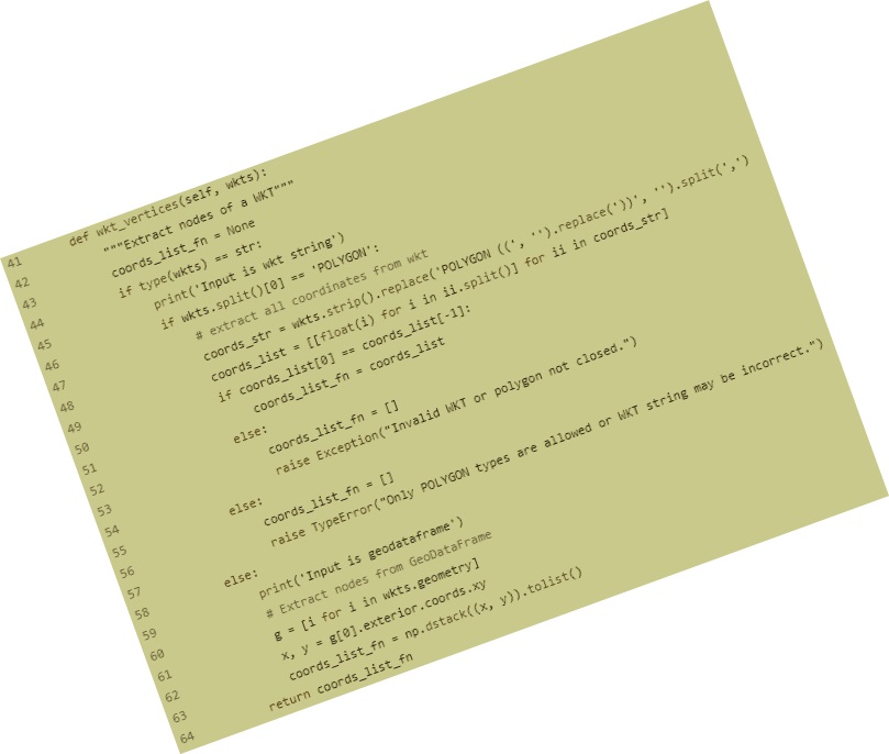
Hello,
my name is Debabrata Ghorai
I'm a Data Science enthusiast with a PhD in Remote Sensing and GIS.
Click here to view my PhD thesis:
View My Thesis

About Me

I'm Debabrata and I'm a

✔️ I discovered my passion for data science working as an engineer in remote sensing for several years. I believe in self-learning and decided to switch my job towards data science and since then I dedicated my time to learning and understanding data science concepts and their practical application. I took a couple of online courses to get the inside about this field and then attained professional certification course on data science.

✔️ At the beginning everything was new to me except some programming languages: Python, R, and C/C++. I learned intermediate to advanced level Python programming and its various machine learning libraries: OpenCV for object recognition, Scikit-learn for end-to-end machine learning pipeline building, Keras-Tensorflow framework for Deep learning, Flask for web application, and many others. During the learning phase I worked on my portfolio project where I familiar with HTML and CSS web development tools.

✔️ My areas of interests include Computer Vision, Machine Learning, Geospatial Research, and Software Development. In my free time, I like to watch movies, research article writing, and traveling to new place.

🙂 🙂 🙂 🙂 🙂

View My Resume

🧑‍💻 My Services

Geospatial Analytics

Proficient in creating thematic maps from geospatial data and have ability to make decision from geospatial data.

AI/ML Model

Efficient in developing production ready machine learning model of a data science project.

Data Analytics

Expertise in extraction of insights from data using exploratory data analysis (EDA) techniques with data visualization.

🦸🏻 My Expertise

✍️ Subject matter experts and a data scientist with hands-on experience in satellite image processing, machine learning model development, backend development, and geospatial data analysis.

✍️ Proficient in predictive modeling, data engineering, and data mining algorithms, as well as coding languages.

✍️ Experienced in implementing action-oriented solutions to complex business problems on crop analytics, flood hazard mapping, coastal vulnerability analysis, and land use/land cover mapping.


Technical Stack

☑️Python, R, SQL, NoSQL, HTML, and C/C++

☑️Pandas, Geopandas, Scikit-learn, OpenCV, Keras, Tensorflow, GDAL, Flask, NumPy, SciPy, Matplotlib, Seaborn, NLTK, Tkinter, shapely, tsfresh, earthengine-api, Py6S, and json

☑️AWS Lambda, S3 Bucket, EC2 Instance, and Amazon DynamoDB

☑️Spyder, PyCharm, VSCode, Jupyter Notebook, Google Colab, Git, DBeaver, QGIS, ArcGIS, ERDAS Imagine, PostgreSQL, SQLite, Bootstrap, CSS, JavaScript, MongoDB, PowerBI, Tableau, and ENVI

☑️Operating System: Windows, Ubuntu (Linux)


Data Science Skills
Supervised/Unsupervised Machine Learning
Neural Networks and Deep Learning
Natural Language Processing
Object Detection, Segmentation, Tracking, Counting and Classification
Statistics, EDA, Data Cleaning, and Data Visualization

📝 My Projects

💡 My Research

Get in touch

My geo-location

View Larger Map
E-mail me if you require assistance in developing AI/ML models or geospatial/data analytics.